In April 2024, maritime trackers logged 117 ships sitting on the runway of Beirut Airport. None of them were there. Falsified satellite signals had rewritten their positions all at once, a vivid sign of how fragile location technology has become. GPS tracking now underpins logistics, safety, and entire infrastructures, yet most explanations stop at the idea that satellites find a location.
The reality is more layered. A tracker is not one technology but a stack of three: the positioning that works out where something is, the connectivity that reports it back, and the platform that stores and often sells the result. Benefits, limitations, and security all behave differently across those layers, and understanding them separately is the difference between using location technology well and trusting it blindly.
What GPS Tracking Actually Is
The first thing to clear up is a naming confusion. GPS is a single system, owned and operated by the United States. The broader category is GNSS, which also includes Russia's GLONASS, Europe's Galileo, China's BeiDou, and regional systems such as India's NavIC and Japan's QZSS. Most modern receivers use several of these at once for a faster and steadier fix.
The second surprise is larger: many devices sold as trackers contain no satellite receiver at all. A Bluetooth tracker such as an AirTag or a Tile has no GPS inside it. Instead it broadcasts a short-range signal that nearby smartphones pick up and relay, so its location is really being reported by other people's phones. That distinction matters, because the privacy and security profile of a crowdsourced tracker is entirely different from that of a true satellite tracker.
Across all of these, the same three-layer structure holds.
| Layer | What it does | Common technologies |
| Positioning | Determines where the device is | GNSS, cellular and wifi positioning, crowdsourced Bluetooth |
| Connectivity | Reports the location back | Cellular, satellite uplink, LoRa, Bluetooth relay |
| Platform | Stores, displays, and shares the data | Cloud servers, mobile apps, APIs, data marketplaces |
Keeping these layers separate is the key to the rest of this article, because a weakness in one is not a weakness in the others.
How the Positioning Works
A satellite receiver does not ask a satellite where it is. It listens. Each satellite continuously broadcasts its own position and an extremely precise time stamp, and the receiver measures how long each signal took to arrive. With signals from four or more satellites, it can solve for both its location and the exact time, a process known as trilateration.
One physical fact from this process explains almost every weakness that follows. The signals travel roughly 20,000 kilometers and arrive incredibly faint, weaker than the background radio noise around them, and a receiver only recovers them through careful signal processing. That fragility is the reason a small, inexpensive transmitter on the ground can drown them out or replace them, a point that returns in the security discussion below.
Where It Delivers Value
The benefits reach far beyond following a dot on a map, and they are easiest to understand by mechanism rather than by industry.
• Fleet and logistics. Continuous position and route data cut fuel use, prove deliveries, and allow rerouting around delays in real time.
• Asset and supply-chain visibility. Tracking high-value cargo and equipment flags the moment something stops moving or leaves an expected zone.
• Personal and lone-worker safety. Location becomes a lifeline, sending coordinates automatically when someone triggers an alert or stops responding.
• Emergency response and precision work. Services locate callers in distress, while agriculture and construction use centimeter-grade correction to steer machinery within inches.
• Recovery and telematics. Owners trace stolen vehicles and equipment, and insurers price policies on actual driving behavior rather than estimates.
One benefit is almost always overlooked: satellite systems deliver extraordinarily precise time, not just position. Power grids, financial trading systems, and mobile networks quietly synchronize themselves using that timing signal, which is why a navigation problem can quickly become an infrastructure problem.
Where It Falls Short
Accuracy is the most misunderstood part of the technology, because there is no single figure. Where a device sits matters enormously.
| Environment | Typical behavior |
| Open sky | A few meters, reliable and steady |
| Urban canyon | Degraded, as signals bounce off buildings and confuse the receiver |
| Dense foliage or indoors | Weak to unusable, since the faint signal cannot penetrate |
| With correction (RTK or augmentation) | Centimeter level, but requires extra infrastructure |
Several limitations are structural rather than situational. The bouncing of signals off surfaces, called multipath, is the main reason dense cities are difficult. Receiver quality matters too, with dual-frequency chips far more resistant to error than older single-frequency ones.
Beyond accuracy, the system as a whole has practical limits: a tracker with no working connectivity path is blind no matter how good its fix, faster update rates drain batteries quickly, and a cold start can take a minute or more to find enough satellites. Positioning, connectivity, and power are always in tension, and a tracker is only as useful as its weakest layer.
Security: Three Separate Problems
Security gets flattened in most explanations into a single warning about protecting data. In practice it splits into three distinct classes of risk, each affecting a different layer of the stack, and each calling for a different defense. The sections that follow address them in turn.
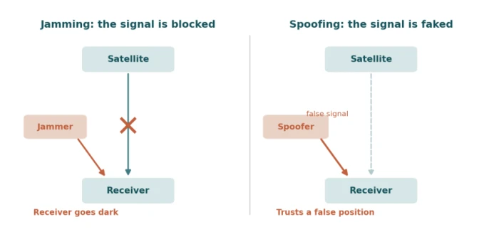
Attacks on the Signal
Signal-layer attacks come in two forms that are often confused, and the difference matters. Jamming is denial: a transmitter floods the frequency with noise so the receiver gets nothing and the device goes dark. Spoofing is deception: a transmitter sends false but convincing signals, and the receiver computes a wrong position while believing it is correct. Spoofing is the more dangerous of the two precisely because the device trusts the lie.
These attacks are no longer rare or theoretical, and the scale of real-world interference has climbed sharply, especially around conflict zones. Germany alone recorded 447 incidents affecting civilian aircraft between January and August 2025, against just 25 in all of 2023. Nearly 123,000 flights over Baltic airspace were affected in the first four months of 2025, and the GPS aboard a plane carrying a senior European official was disrupted in a suspected jamming attack.
Researchers tracking the activity note that through 2025 it shifted from mostly blocking signals toward mostly falsifying them. The maritime picture is just as stark: beyond the vessels misplaced near Beirut, more than 3,000 ships were disrupted in the Persian Gulf and the Strait of Hormuz within two weeks in June 2025.
The defense is instructive for any critical system. Commercial aircraft carry several independent navigation systems and fall back to them when interference appears, a reminder that resilience comes from redundancy rather than from trusting one source.
The Platform Is the Real Target
The satellites are rarely the weak point. The server usually is. A modern tracker is an internet-connected device tied to a cloud platform, a mobile app, and an API, and that backend carries the same risks as any connected system. Weak default passwords, exposed interfaces, and breachable databases mean an attacker can often retrieve a target's entire location history without touching a single radio signal.
This is the layer most explanations ignore, and it is frequently the easiest to exploit. A spoofing attack needs equipment and physical proximity, while pulling location data from a poorly secured tracking platform may need nothing more than a guessed password. For any organization deploying trackers, the location data sitting on a server deserves more attention than the signal in the sky.
The Privacy Problem
Location is among the most revealing data a person generates. A continuous trail exposes home and workplace, medical visits, relationships, and daily routine. Two distinct threats follow from that sensitivity.
The first is covert tracking of individuals. Inexpensive Bluetooth trackers, designed to find keys and luggage, have been turned into stalking tools. A 2022 lawsuit brought on behalf of 38 people alleged that AirTags were being used to follow people without consent, and the misuse extends to thieves tagging cars to locate and later steal them. The response has been both technical and legal. Apple and Google built a shared standard that alerts a phone when an unknown tracker is moving with its owner, now available across recent iPhone and Android versions, and several jurisdictions have made covert tracking a serious crime, with some treating it as a felony.
The second threat is larger and quieter, because it is entirely legal. Many apps collect location through embedded software kits and sell it through advertising auctions to data brokers. Regulators have begun pushing back hard. The United States Federal Trade Commission issued its first-ever ban on selling sensitive location data in early 2024, then acted against several brokers, including one that claimed to process more than 17 billion location signals from roughly a billion devices every day, and barred another from selling data that could pinpoint a person's home. The uncomfortable takeaway is that the biggest erosion of location privacy is not a hack but a business model.
The Legal and Ethical Line
Whether tracking is acceptable usually turns on consent. Tracking a partner or another adult without their knowledge is generally illegal, while an employer monitoring company vehicles or a parent locating a young child sits in more accepted but still contested territory. The rules vary widely by jurisdiction, and the same device can be lawful in one use and criminal in another. A second question follows the data itself: who owns the location history a tracking service collects, how long it is kept, and who else can reach it. Anyone deploying tracking, whether a business or an individual, is responsible for answering those questions before switching it on.
The Bigger Risk: Quiet Over-Reliance
The most serious long-term concern is how invisibly the technology has woven itself into critical infrastructure. Because satellite systems provide positioning, navigation, and precise timing all at once, a single point of failure now sits beneath power grids, financial networks, telecommunications, and transport. The interference surge is a warning that this dependence has grown faster than its safeguards. The concern is now official: in January 2026, thirteen coastal European nations and Iceland jointly flagged growing satellite interference and moved to reinforce safety requirements, while interest in backup and complementary systems is rising. Treating one fragile signal as permanently available is the deeper vulnerability.
Using It Safely
The technology is neither flawless nor dangerous; it rewards informed use. The practical steps differ by who is doing the tracking.
• For individuals. Review which apps hold location permission and revoke whatever is unnecessary, adjust the device settings that let data brokers link movements over time, and treat unknown-tracker alerts as worth investigating rather than dismissing.
• For organizations. Choose multi-constellation receivers with anti-spoofing features for anything safety-critical, secure the tracking platform and its API as carefully as the device itself, keep only the location data genuinely needed and delete the rest, and confirm the legal basis for whatever is being tracked.
The common thread is that good location practice is mostly about the layers on the ground, not the satellites overhead.
The Verdict
GPS tracking is far more capable, and far more fragile, than the familiar dot on a map suggests. Its value is real and broad, from logistics and safety to the precise timing that quietly keeps infrastructure running. Its weaknesses are equally real, and they live on different layers: a signal so faint it can be jammed or faked with cheap equipment, a platform that is often the softest target of all, and a data trail exploited far more through legal commerce than through any attack.
The technology is not something to fear, nor something to trust uncritically. It is something to understand layer by layer. The organizations and individuals who treat positioning, connectivity, and platform as separate problems, each with its own benefits and its own risks, will capture the enormous value location technology offers without inheriting the blind spots that come from believing the satellites alone tell the whole story.
Comments
Join the discussion and share your perspective.